Hot, dry weather to start the weekend, adding to wildfire risk in southern Alberta
Heat warnings continue across the southern portion of Alberta, Saskatchewan and British Columbia, with both daytime high and low temperatures expected to exceed normal thresholds.
Environment and Climate Change Canada (ECCC) will issue a heat warning for most of Alberta when daily maximum temperatures are expected to reach at least 29 C along with daily minimum temperatures of at least 14 C for at least two consecutive days.
For details on heat warning threshold criteria from ECCC click here.
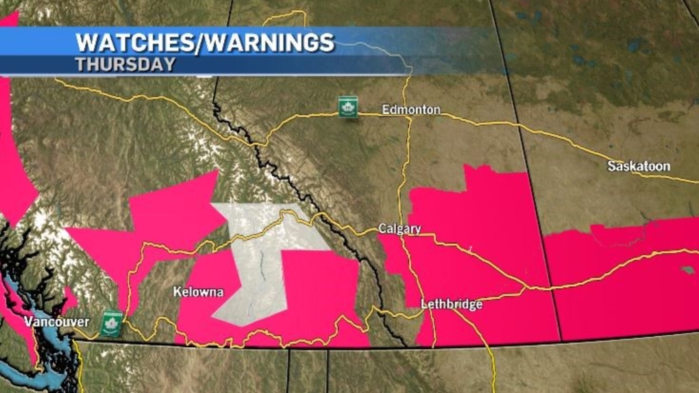 Heat warnings (pink) and air quality advisories (grey) issued by Environment and Climate Change Canada on Aug. 1.
The source of this heat is a ridge of high pressure that extends to the southern U.S. but unlike the stationary ridge from July, this ridge will track to the east by the middle of the weekend.
As the ridge does move out, convective weather (thunderstorms) are possible in central and southern Alberta, which is less than ideal with an elevated wildfire risk.
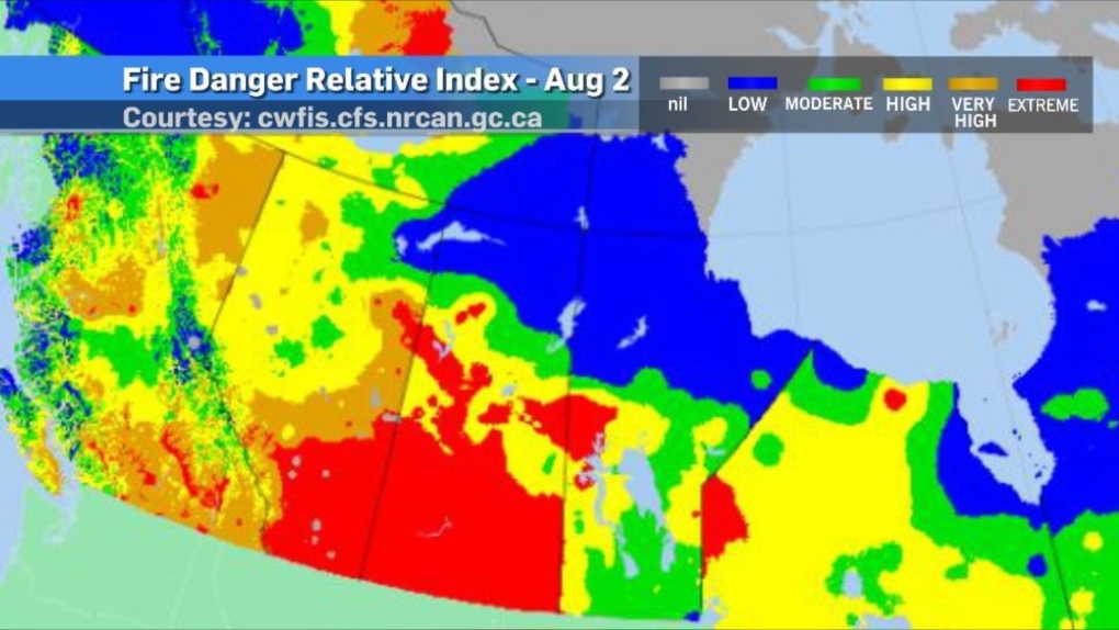
As of 6 p.m. on Thursday, all of southern Alberta and southern Saskatchewan were under an “extreme” risk according to the Fire Danger Relative Index.
This is an evaluation of a number of potential risks but can be summarized in three parts: How likely it is for a wildfire to start, how difficult it would be to extinguish a wildfire if one does start and how much damage could be done.
Since this is a relative index, it can change considerably from day to day due to weather conditions (and other factors).
The forecast outlook for Friday shows a smaller region in southern Alberta under an extreme risk with an increased risk (to “high” for most of Alberta).
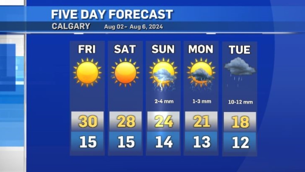
In Calgary, daytime highs will drop to below-seasonal temperatures by Monday, and rain is possible from Sunday until Tuesday.
View original article here Source

Queen Size 4 Piece Sheet Set - Comfy Breathable & Cooling Sheets - Hotel Luxury Bed Sheets for Women & Men - Deep Pockets, Easy-Fit, Extra Soft & Wrinkle Free Sheets - White Oeko-Tex Bed Sheet Set
$29.99 (as of September 3, 2024 08:27 GMT -05:00 - More infoProduct prices and availability are accurate as of the date/time indicated and are subject to change. Any price and availability information displayed on [relevant Amazon Site(s), as applicable] at the time of purchase will apply to the purchase of this product.)
Stanley Quencher H2.0 FlowState Stainless Steel Vacuum Insulated Tumbler with Lid and Straw for Water, Iced Tea or Coffee, Smoothie and More, Rose Quartz 2.0, 30 OZ / 0.89 L
$46.00 (as of September 3, 2024 08:27 GMT -05:00 - More infoProduct prices and availability are accurate as of the date/time indicated and are subject to change. Any price and availability information displayed on [relevant Amazon Site(s), as applicable] at the time of purchase will apply to the purchase of this product.)
KIDMI Women's Suede Clogs Leather Mules Cork Footbed Sandals Potato Shoes with Arch Support
$55.99 (as of September 3, 2024 08:27 GMT -05:00 - More infoProduct prices and availability are accurate as of the date/time indicated and are subject to change. Any price and availability information displayed on [relevant Amazon Site(s), as applicable] at the time of purchase will apply to the purchase of this product.)
Hanes Men’s Ribbed Tank
$20.97 (as of September 3, 2024 08:27 GMT -05:00 - More infoProduct prices and availability are accurate as of the date/time indicated and are subject to change. Any price and availability information displayed on [relevant Amazon Site(s), as applicable] at the time of purchase will apply to the purchase of this product.)
Fitbit Inspire 3 Health and Fitness Tracker with Stress Management, Workout Intensity, Sleep Tracking, 24/7 Heart Rate and More, Midnight Zen/black, One Size (S and L Bands Included)
$99.95 (as of September 3, 2024 08:27 GMT -05:00 - More infoProduct prices and availability are accurate as of the date/time indicated and are subject to change. Any price and availability information displayed on [relevant Amazon Site(s), as applicable] at the time of purchase will apply to the purchase of this product.)
Apple iPhone SE 2020 (64GB, 3GB) 4.7" Retina IPS LCD, A13 Bionic, IP67 Water Resistant, Black - Fully Unlocked A2275 (Renewed)
$180.39 (as of September 3, 2024 08:27 GMT -05:00 - More infoProduct prices and availability are accurate as of the date/time indicated and are subject to change. Any price and availability information displayed on [relevant Amazon Site(s), as applicable] at the time of purchase will apply to the purchase of this product.)
2019 Apple iPad (10.2-Inch, Wi-Fi, 32GB) - Space Gray (Renewed)
$235.00 (as of September 3, 2024 08:27 GMT -05:00 - More infoProduct prices and availability are accurate as of the date/time indicated and are subject to change. Any price and availability information displayed on [relevant Amazon Site(s), as applicable] at the time of purchase will apply to the purchase of this product.)
Apple iPad 2018 32GB - WiFi Only - Space Gray (Renewed)
$187.00 (as of September 3, 2024 08:27 GMT -05:00 - More infoProduct prices and availability are accurate as of the date/time indicated and are subject to change. Any price and availability information displayed on [relevant Amazon Site(s), as applicable] at the time of purchase will apply to the purchase of this product.)
Utopia Bedding Waterproof Mattress Protector Queen Size, Viscose Made from Bamboo Mattress Cover 200 GSM, Fits 17 Inches Deep, Breathable, Fitted Style with Stretchable Pockets
$33.99 (as of September 3, 2024 08:27 GMT -05:00 - More infoProduct prices and availability are accurate as of the date/time indicated and are subject to change. Any price and availability information displayed on [relevant Amazon Site(s), as applicable] at the time of purchase will apply to the purchase of this product.)