Get ready for a drop in temperatures: Arctic fronts forecast across much of Canada
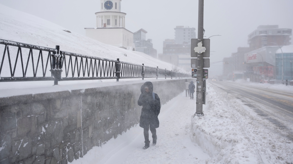
Canadians may be enjoying what felt like an early start to spring, but temperatures are set to drop, according to CTV Your Morning’s meteorologist Kelsey McEwen.
McEwen said Thursday that provinces including Ontario, Quebec, the Prairies and parts of B.C. are expected to face wintry weather conditions brought on by approaching arctic fronts.
After a couple of days of balmy weather, Ontario and Quebec can expect a temperature drop by the weekend, hitting 10 C colder Saturday afternoon than Thursday. The sweeping cold front will bring snow and strong winds, McEwen said. Blowing snow and wind chills are forecast.
Extreme cold is expected in northern Quebec, with wind chills nearing -52 Thursday night and warming up through Friday morning.
Environment Canada said the wind chill is a combination of cold temperatures and westerly winds.
Further west, temperatures will fall below zero across Alberta, Saskatchewan and Manitoba on Saturday. McEwen said that the eastern Prairies can expect the temperature to drop past the freezing mark at the tail end of the weekend and early next week.
In Nunavut, areas like Chesterfield Inlet and Arviat faced wind chills of -55 or lower Thursday morning.
Heavy snowfall
According to McEwen, active weather is forecast for the B.C., with snow and rain descending south.
Environment Canada issued a snowfall warning for the north coast, with 15 centimetres set to fall Thursday evening till Friday morning. Heavy snow will taper off to showers or wet flurries early Friday afternoon before snowfall returns Friday night.
According to the weather agency, an air quality statement was issued for parts of B.C., including North Peace River and the Lakes District.
The air advisories were issued “due to high concentrations of fine particulate matter that are expected to persist until weather conditions change.”
Freezing rain
A storm is brewing for Atlantic Canada as freezing rain is expected to hit Newfoundland and Labrador, including the Avalon Peninsula and St. John’s.
Residents should watch out for 10 to 22 millimetres of ice buildup due to eight to 10 hours of freezing rain. McEwen said the storm will start with snow and ice pellets before moving into rain or freezing rain.
Environment Canada warned motorists that roads will be icy and hazardous during the Friday morning commute even though the freezing rain is expected to be over by then.
“Utility outages may occur,” the weather agency said.
A special weather statement was issued for Bonavista Peninsula and Clarenville as freezing rain is expected over a span of four hours or more, with five to 15 centimetres of snow and ice pellets expected during that time as well. The weather conditions will kick off Thursday evening, lasting into early Friday morning, Environment Canada said.
According to the statement, it’s uncertain whether Thursday night’s precipitation will fall as ice pellets or freezing rain.
A special weather statement in Nova Scotia notes 25 to 55 millimetres of rain on frozen ground, with winds ranging from 70 to 90 km/h expected Friday evening until Saturday.
Impacted areas include Halifax, Richmond, Inverness and Colchester County.
Environment Canada said similar storms have caused water pools on roadways and flooding in low-lying areas.
“Be sure to clear storm drains and gutters of ice and other debris,” the weather agency said.
View original article here Source

Organika Enhanced Collagen Peptides Protein Powder For Healthy Hair, Skin, Nails, Joints - Hydrolyzed For Better Absorption – Grass-Fed, Non-GMO - Unflavoured, white/beige, 50 Servings (Pack of 1)
$39.98 (as of April 13, 2024 20:25 GMT -05:00 - More infoProduct prices and availability are accurate as of the date/time indicated and are subject to change. Any price and availability information displayed on [relevant Amazon Site(s), as applicable] at the time of purchase will apply to the purchase of this product.)
Sunzel Workout Leggings for Women, Squat Proof High Waisted Yoga Pants 4 Way Stretch, Buttery Soft
$36.99 (as of April 13, 2024 20:25 GMT -05:00 - More infoProduct prices and availability are accurate as of the date/time indicated and are subject to change. Any price and availability information displayed on [relevant Amazon Site(s), as applicable] at the time of purchase will apply to the purchase of this product.)
Sfee 2 Pack Microfiber Travel Towel, Quick Dry Towel Camping Towel Beach Towels, Super Absorbent Compact Lightweight Sport Towel Gym Towel for Travel, Beach, Hiking, Gym, Pool, Bath, Yoga, Backpacking
$16.15 (as of April 13, 2024 20:25 GMT -05:00 - More infoProduct prices and availability are accurate as of the date/time indicated and are subject to change. Any price and availability information displayed on [relevant Amazon Site(s), as applicable] at the time of purchase will apply to the purchase of this product.)
Sunstar 888JC GUM Advanced Care Flossers, Fresh Mint, Vitamin E & Fluoride, 150 Count (packaging may vary)
$5.77 (as of April 13, 2024 20:25 GMT -05:00 - More infoProduct prices and availability are accurate as of the date/time indicated and are subject to change. Any price and availability information displayed on [relevant Amazon Site(s), as applicable] at the time of purchase will apply to the purchase of this product.)
Zulay Powerful Milk Frother Handheld Foam Maker for Lattes - Whisk Drink Mixer for Coffee, Mini Foamer for Cappuccino, Frappe, Matcha, Hot Chocolate by Milk Boss (Black)
$13.39 (as of April 13, 2024 20:25 GMT -05:00 - More infoProduct prices and availability are accurate as of the date/time indicated and are subject to change. Any price and availability information displayed on [relevant Amazon Site(s), as applicable] at the time of purchase will apply to the purchase of this product.)
Rael Miracle Invisible Spot Cover - Absorbing Cover, Skin Care, Facial Stickers, 2 Sizes (96 Count)
$24.99 (as of April 13, 2024 20:25 GMT -05:00 - More infoProduct prices and availability are accurate as of the date/time indicated and are subject to change. Any price and availability information displayed on [relevant Amazon Site(s), as applicable] at the time of purchase will apply to the purchase of this product.)
Queen Size 4 Piece Sheet Set - Comfy Breathable & Cooling Sheets - Hotel Luxury Bed Sheets for Women & Men - Deep Pockets, Easy-Fit, Extra Soft & Wrinkle Free Sheets - White Oeko-Tex Bed Sheet Set
$29.99 (as of April 13, 2024 20:25 GMT -05:00 - More infoProduct prices and availability are accurate as of the date/time indicated and are subject to change. Any price and availability information displayed on [relevant Amazon Site(s), as applicable] at the time of purchase will apply to the purchase of this product.)
Gritin Resistance Bands, [Set of 5] Skin-Friendly Resistance Fitness Exercise Loop Bands with 5 Different Resistance Levels - Free Carrying Case Included - Ideal for Home, Gym, Yoga, Training
$14.99 (as of April 13, 2024 20:25 GMT -05:00 - More infoProduct prices and availability are accurate as of the date/time indicated and are subject to change. Any price and availability information displayed on [relevant Amazon Site(s), as applicable] at the time of purchase will apply to the purchase of this product.)
Retrospec Solana Yoga Mat 1/2" Thick w/Nylon Strap for Men & Women - Non Slip Excercise Mat for Yoga, Pilates, Stretching, Floor & Fitness Workouts, Black
$33.36 (as of April 13, 2024 20:25 GMT -05:00 - More infoProduct prices and availability are accurate as of the date/time indicated and are subject to change. Any price and availability information displayed on [relevant Amazon Site(s), as applicable] at the time of purchase will apply to the purchase of this product.)