Tornado, severe thunderstorm watches issued for parts of Manitoba and Ontario
After a soggy, chaotic few days in Manitoba, more severe thunderstorms could be on the way to parts of the province on Thursday.
Environment and Climate Change Canada (ECCC) has issued severe thunderstorm watches and warnings for a large section of central and northern Manitoba including The Pas, Norway House, Grand Rapids, Easterville, Island Lake, and Poplar River.
The weather agency said its meteorologists are tracking severe thunderstorms in the area capable of producing very strong wind gusts, up to nickel size hail, and heavy rain.
ECCC reminded the public that large hail can damage property and cause injury, while strong wind gusts can toss loose objects, damage weak buildings, break branches off trees, and overturn vehicles.
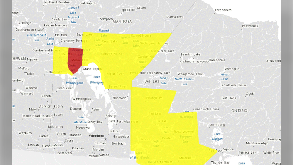 Areas affected by severe thunderstorm watches, warnings, as well as a tornado watch, are pictured on Environment and Climate Change Canada’s website on Sept. 19, 2024.
The agency also warned intense lightning is likely with any thunderstorm that develops.
There is also a tornado watch in effect for parts of northwestern Ontario, including Kenora, Fort Frances, and Dryden.
ECC said thunderstorms are expected to develop along or ahead of a cold front moving eastwards across the area, which could produce tornadoes.
In the event of a tornado or if a tornado warning is issued for your area, ECCC recommends going inside to a room on the lowest floor, away from outside walls and windows, like a basement, bathroom, stairwell, or interior closet.
You should also leave mobile homes, vehicles, tents, trailers, and other temporary or free-standing shelters, and move to a strong building.
“As a last resort, lie in a low spot and protect your head from flying debris. Lightning kills and injures Canadians every year. Remember, when thunder roars, go indoors,” ECCC said.
View original article here Source

Pure Protein Bars - Nutritious, Gluten Free protein bar, made with Whey protein blend - low sugar, protein snack.…
$12.98 (as of September 19, 2024 09:00 GMT -05:00 - More infoProduct prices and availability are accurate as of the date/time indicated and are subject to change. Any price and availability information displayed on [relevant Amazon Site(s), as applicable] at the time of purchase will apply to the purchase of this product.)
Bounty Select-A-Size Paper Towels, 8 Double Plus Rolls = 20 Regular Rolls, White
$29.98 (as of September 19, 2024 09:00 GMT -05:00 - More infoProduct prices and availability are accurate as of the date/time indicated and are subject to change. Any price and availability information displayed on [relevant Amazon Site(s), as applicable] at the time of purchase will apply to the purchase of this product.)
Sahara Sailor Water Bottle, 32oz Motivational Sports Water Bottle with Time Marker - Times to Drink - Tritan, BPA Free,…
$15.99 (as of September 19, 2024 09:00 GMT -05:00 - More infoProduct prices and availability are accurate as of the date/time indicated and are subject to change. Any price and availability information displayed on [relevant Amazon Site(s), as applicable] at the time of purchase will apply to the purchase of this product.)
GUM Advanced Care Flosser Picks, Infused with Vitamin E & Fluroide, Fresh Mint Flavour, Blue, 150 Flossers (1 Bag)
$5.99 (as of September 19, 2024 09:00 GMT -05:00 - More infoProduct prices and availability are accurate as of the date/time indicated and are subject to change. Any price and availability information displayed on [relevant Amazon Site(s), as applicable] at the time of purchase will apply to the purchase of this product.)
Diapers Size 4, 150 Count - Pampers Swaddlers Disposable Baby Diapers (Packaging & Prints May Vary)
$42.63 (as of September 19, 2024 09:00 GMT -05:00 - More infoProduct prices and availability are accurate as of the date/time indicated and are subject to change. Any price and availability information displayed on [relevant Amazon Site(s), as applicable] at the time of purchase will apply to the purchase of this product.)
Amazon Basics 1/2-Inch Extra Thick Exercise Mat with Carrying Strap
$27.32 (as of September 19, 2024 09:00 GMT -05:00 - More infoProduct prices and availability are accurate as of the date/time indicated and are subject to change. Any price and availability information displayed on [relevant Amazon Site(s), as applicable] at the time of purchase will apply to the purchase of this product.)
Yes4All Neoprene Coated Dumbbell Hand Weight Sets of 2 - Multiple Weight Options with 15 Colors, Hexagon Shape,…
$21.10 (as of September 19, 2024 09:00 GMT -05:00 - More infoProduct prices and availability are accurate as of the date/time indicated and are subject to change. Any price and availability information displayed on [relevant Amazon Site(s), as applicable] at the time of purchase will apply to the purchase of this product.)
Sudocrem - Diaper Rash Cream for Baby, Soothes, Heals, and Protects, Relief and Treatment of Diaper Rash, Zinc Oxide…
$14.97 (as of September 19, 2024 09:00 GMT -05:00 - More infoProduct prices and availability are accurate as of the date/time indicated and are subject to change. Any price and availability information displayed on [relevant Amazon Site(s), as applicable] at the time of purchase will apply to the purchase of this product.)
e11ement - Hypochlorous Acid All Natural Face and Skin Spray - Safe for All Skin Types - Acne Prone Skin - Dry Face, Skin,…
$18.95 (as of September 19, 2024 09:00 GMT -05:00 - More infoProduct prices and availability are accurate as of the date/time indicated and are subject to change. Any price and availability information displayed on [relevant Amazon Site(s), as applicable] at the time of purchase will apply to the purchase of this product.)